Network map · 18 September 2026
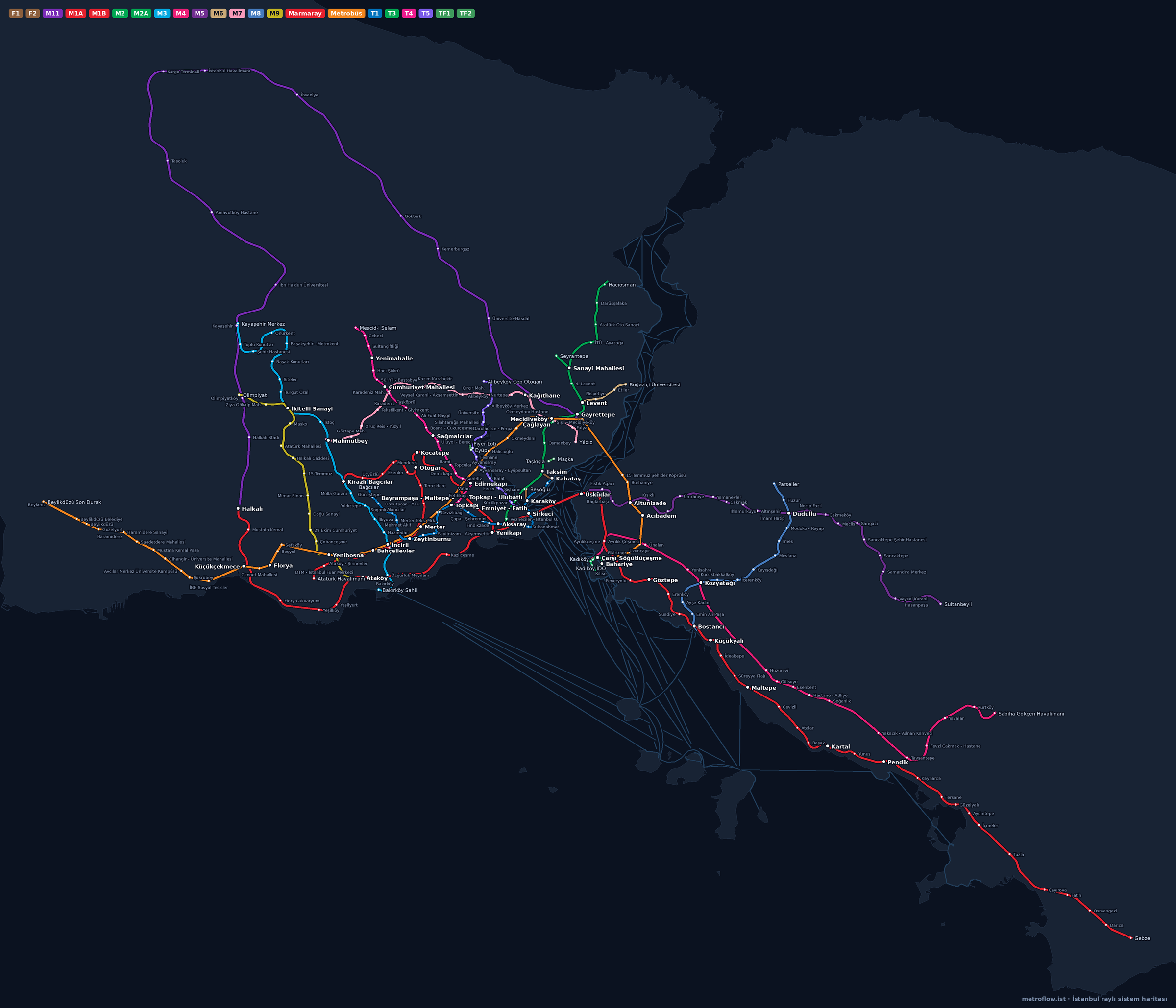
Istanbul Metro and Rail Network Map
22 lines, 289 stations and 45 ferry piers on a real street map: metro, Marmaray, trams, funiculars, cable cars, Metrobüs and ferries. Tap a station for its lines, first/last trains and frequency; tap a pier for the next sailings; “Near me” finds the closest stop. Pick Bus to show bus stops. Download the high-resolution PNG to keep on your phone; the data is regenerated daily from İBB open data and the Metro İstanbul catalogue.
Download PNG (2400 px) Keep it offline on your phone; printable.
Lines
Metro
- M11Gayrettepe → Halkalı15 stops
- M1AYenikapı → Atatürk Havalimanı18 stops
- M1BYenikapı → Kirazlı Bağcılar13 stops
- M2Yenikapı → Hacıosman15 stops
- M2ASanayi Mahallesi → Seyrantepe2 stops
- M3Bakırköy Sahil → Kayaşehir Merkez20 stops
- M4Kadıköy → Sabiha Gökçen Havalimanı23 stops
- M5Üsküdar → Sultanbeyli24 stops
- M6Levent → Boğaziçi Üniversitesi4 stops
- M7Yıldız → Mahmutbey17 stops
- M8Bostancı → Parseller13 stops
- M9Ataköy → Olimpiyat14 stops
Marmaray
Tram
Frequently asked
Can I download the Istanbul metro map as PDF or JPG?
The button above downloads a 2400-pixel PNG that stays sharp on a phone or printed. The map is regenerated daily under the same file name.
How many lines are on the map?
22 lines and 289 stations: metro (M1A–M11), Marmaray, trams (T1, T3, T4, T5), funiculars (F1, F2), cable cars (TF1, TF2) and the Metrobüs, plus ferry routes as faint lines.
Which stations are interchanges?
White-ringed stations are interchanges: Yenikapı (M1A, M1B, M2, Marmaray), Gayrettepe (M2, M11), Kadıköy (M4, ferries), Üsküdar (M5, Marmaray, ferries), Kabataş (T1, F1, ferries) and more. Tap a station to list its lines.